Hiking

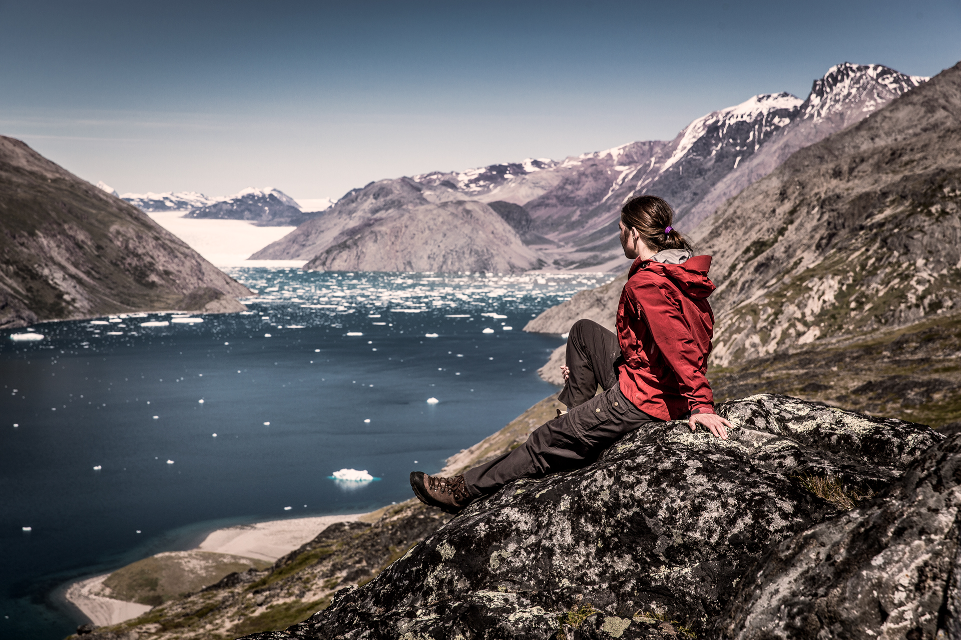
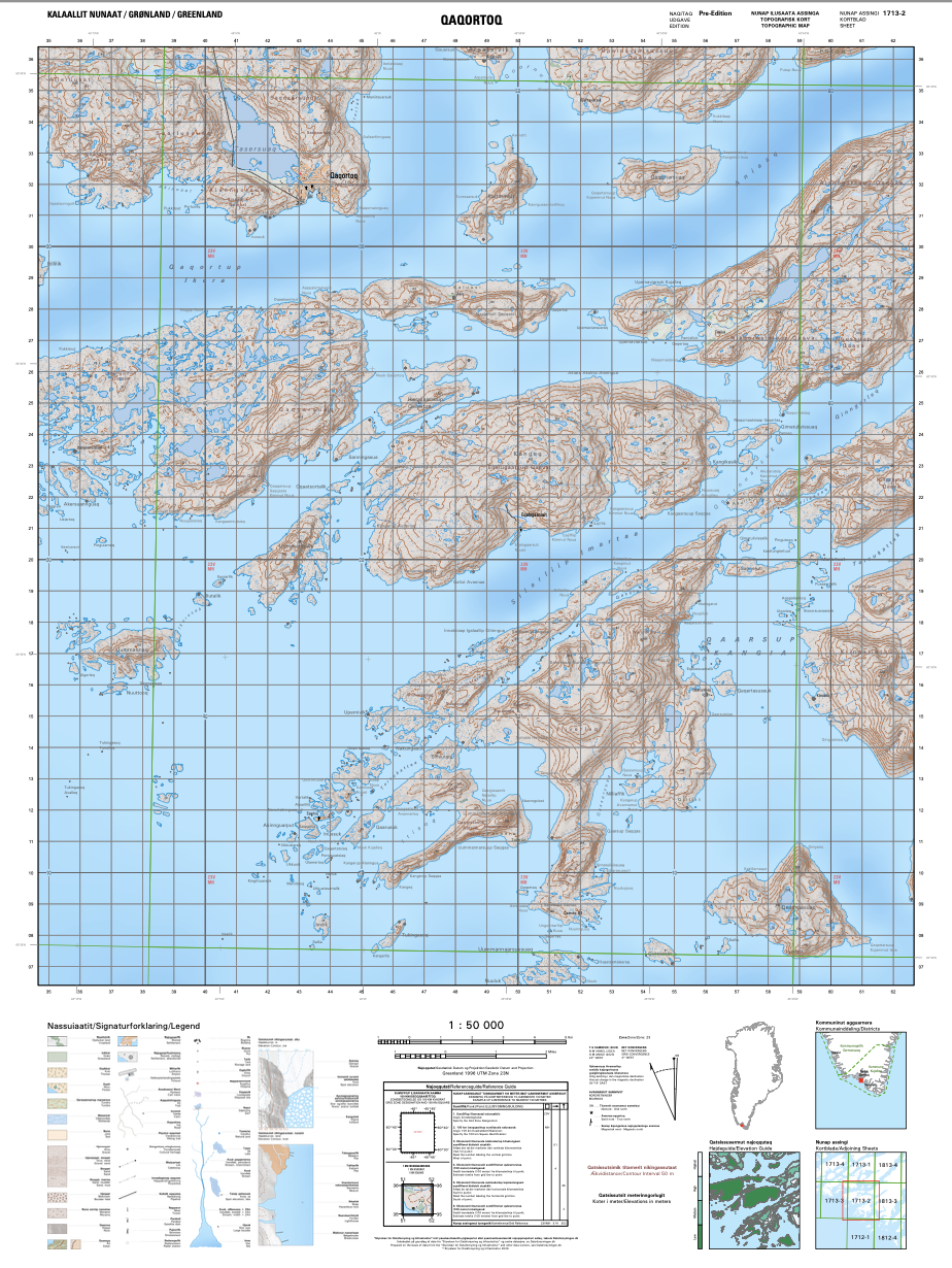
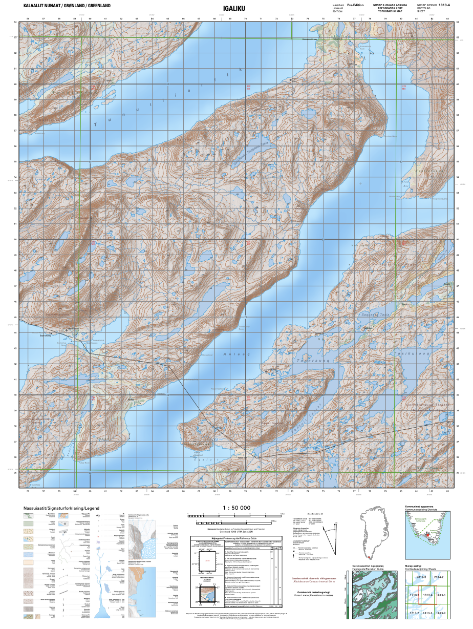
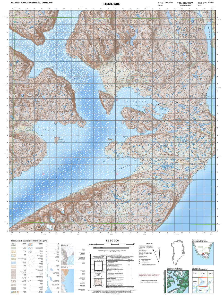
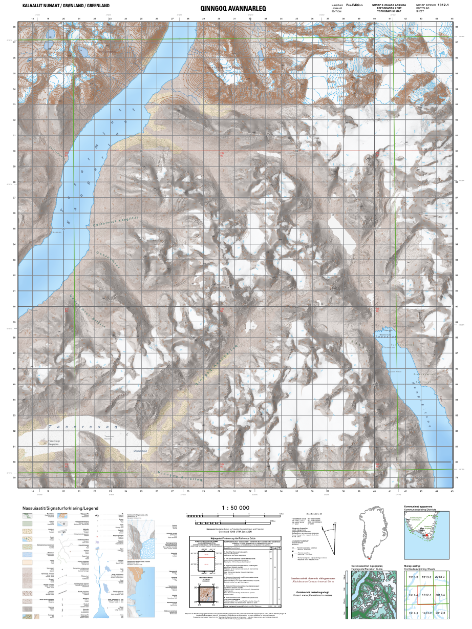
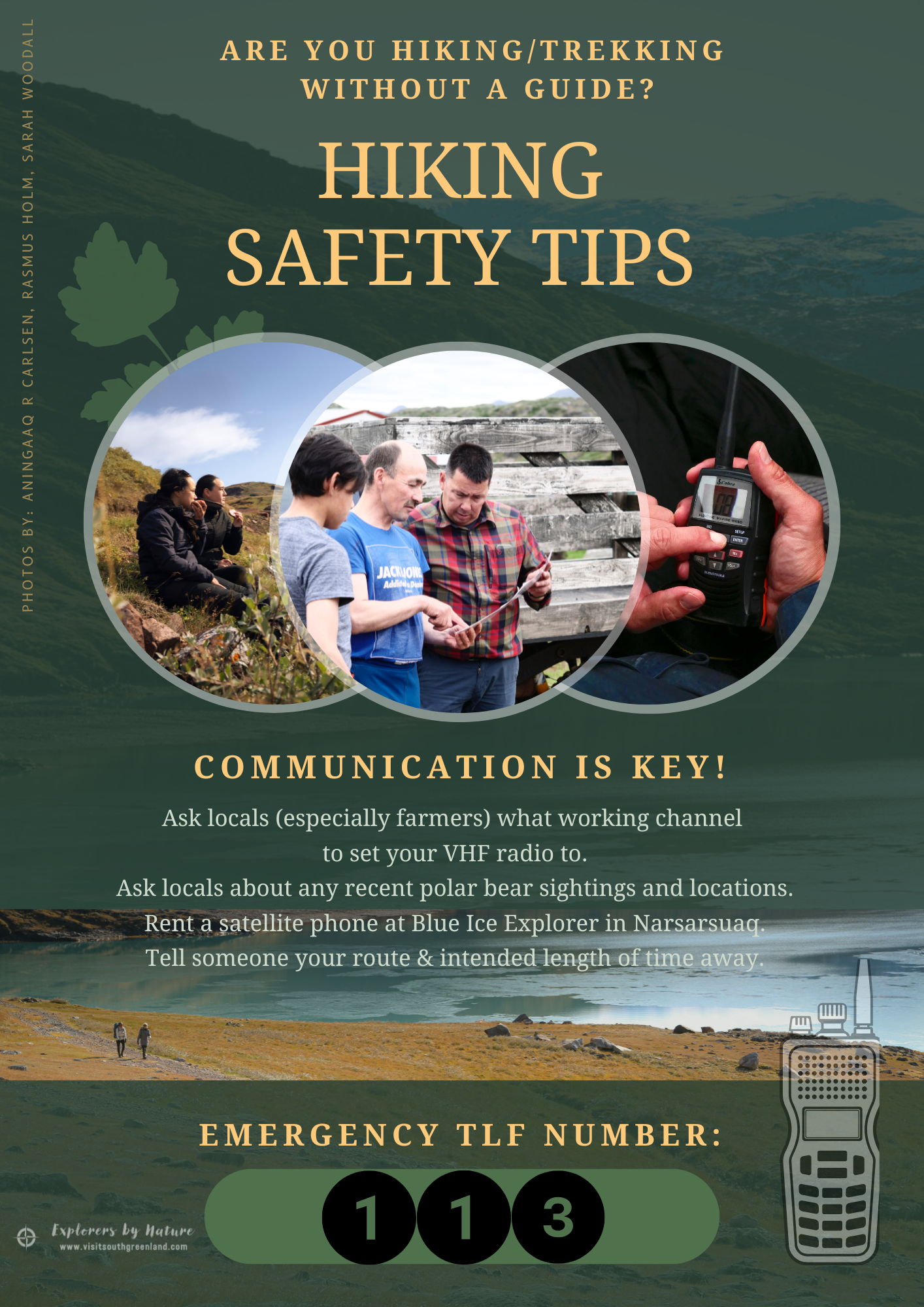
Wherever your two feet stand, there is a hiking opportunity. Follow the sheep farmers' roads from one farm to the next or go off the beaten track through rough terrain. Those reaching the southern fjords will be delighted to hardly see a soul the entire time.

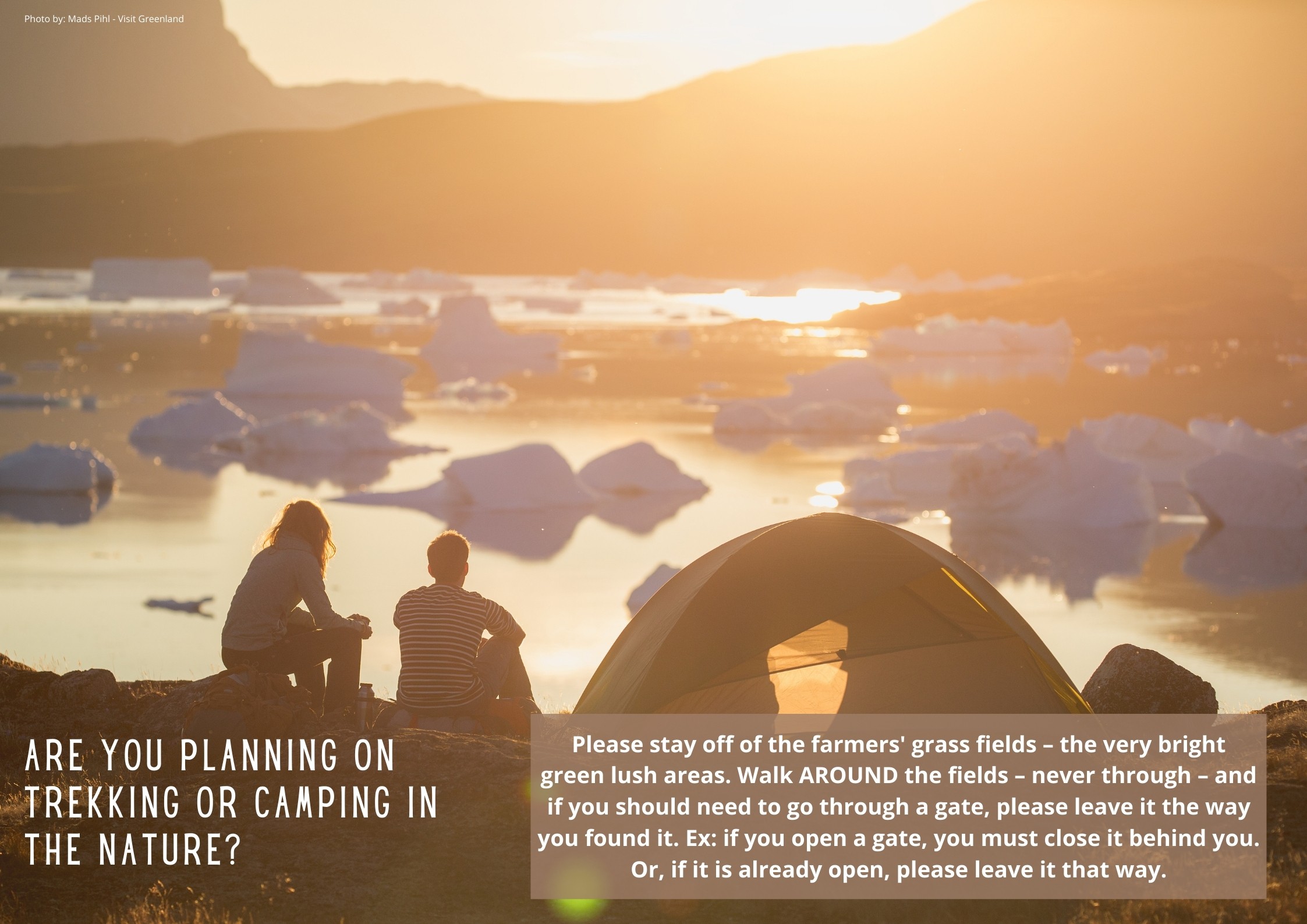
There are only three golden rules to hiking in Greenland: 1) leave no trace, 2) leave gates as you found them (in other words, if you open a gate to pass through, please make sure to close it behind you again), and 3) please do not walk through the farmers' bright green, lush grass fields.

Fabulous Day Hikes

Igaliku
Illerfissalik mountain
Waterfall route

Nanortalik
Qaqqarsuasik mountain

Narsaq
Narsap Ilua

Narsarsuaq
Signal Hill
Hospital Valley
Kiattuut Glacier

Qaqortoq
Around the lake
Saqqarsik mountain
Hare mountain
Killavaat mountain

Qassiarsuk
To Tasiusaq sheep farm
To Inneruulalik & Sillisit sheep farms
To Qorlortup Itinnera sheep farm

See here for a selection of route descriptions


Are you looking for a truly adventurous route that is definitely off the beaten track?
Check out our South Greenland Remote Hiking Guide!

New Downloadable Maps

The Danish institute for data collection and infrastructure (Dataforsyningen) has created an all-encompassing online universe of map material for the entire country of Greenland (as well as for Faroe Islands, Denmark and Europe). The image quality of the maps is extremely high, communicated in Greenlandic, English and Danish, and the system is fed with data from our own Asiaq - Greenland Survey. There are many useful functions within the system such as viewing & downloading satellite pictures. It is also possible to download topographic maps in 1:50.000 scale as PDF files that can be used offline for way-finding via any map app that you most likely already have on your mobile.
Below you can find PDF topographic maps of the most common hiking areas in South Greenland, listed in alphabetical order. (There are additional maps available on our Map of the Region page).

Please feel free to click any map to download. If you use them / recreate them, it is customary to write a source credit to:
Dataforsyningen.dk

Note: the files contain quite a lot of information/data, and therefore it may take time for them to load.

Note: the names below the maps are ones Visit South Greenland has made itself for easy reference. The number codes below the names are the official map ID numbers from Dataforsyningen.dk. 
Most Common Hiking Areas
Nanortalik
GR50_1812-2
Includes the town of Nanortalik and its surrounding mountains accessible by foot, plus the mouth of Tasermiut Fjord
Narsaq, Arpatsivik
GR50_1713-1
Includes the town of Narsaq, the immediate Qaqortoq backcountry, as well as the backcountry route from Qaqortoq toward Area 5 of the UNESCO World Heritage Site, including Qaqortukulooq / Hvalsey Church Ruin and Upernaviarsuk
Narsarsuaq
GR50_2014-2
Includes the settlement Narsarsuaq, Flower Valley toward the Greenland Ice Sheet, the road to the bottom of Tunulliarfik Fjord, Qanassiassat Forest, plus the settlement of Igaliku (within Area 2 of the UNESCO World Heritage Site) and Illerfissalik Mountain
Qaqortoq
GR50_1713-2
Includes the town of Qaqortoq and the area to the south, including the sheep farm Tasiluk and the settlements of Eqalugaarsuit and Saarloq
Qaqortukulooq to Igaliku
GR50_1813-4
Includes the backcountry route from Qaqortukulooq / Hvalsey Church Ruin (Area 5 of the UNESCO World Heritage Site) toward Igaliku (Area 2 of the UNESCO World Heritage Site), as well as the western part of Tasikuluulik (Area 4 of the UNESCO World Heritage Site)
Qassiarsuk
GR50_2014-3
Includes the entirety of Area 1 of the UNESCO World Heritage Site, the settlement Qassiarsuk and surrounding sheep farms like Illunnguujuk, Qorlortup Itinnera, Sillisit & Tasiusaq
Tasermiut East, Kangikitsoq
GR50_1912-1
Includes the known rock climbing mountains Ulamertorsuaq, Suikkassuaq and Naluumasortoq as well as Qinngua Valley at the eastern end of Tasersuaq lake and Kangikitsoq

Safety First

We always recommend first and foremost to use local certified tour companies and guides when out in the nature for hiking holidays, camping trips and other outdoor adventures. These are the people with the local knowledge and 'sixth sense' about our backcountry and wild nature, not to mention first responder certifications (in many cases) and bear safety protocols.

If, however, you will be going out into the backcountry alone, we would like to offer a few key guidelines for those camping on their own without a local guide.

Leave no trace.

Take every single piece of trash you create back with you, and burn all toilet paper instead of stuffing it in the nature.

Inform someone of where you are headed and how long you plan to be away.
Follow up with that person to confirm you have reached your destination.

Do not camp on (or walk on) farmers' bright green grass fields.

Carry and turn on a VHF radio, if you will be within sight of a fjord or the sea.
If you will be deep in a valley, carry a satellite phone.

Protect yourself in the unlikely yet unwanted situation of a polar bear encounter.
We always say that one must be prepared for what can happen, instead of what is likely to happen.
Take flares (sold at local shops), and have easy access to any loud noise makers, like your cooking pots. 
Read more about wildlife encounters.

Local Operators ready to welcome you

Amazing Tours Greenland

Blue Ice Explorer

F Photography x Tours

Guide in Greenland

Greenland Sagalands

NTS Cabins

SG Tours

Sulisartut Højskoliat

Tasermiut Camp

Tasermiut South Greenland Expeditions

Wild Greenland